Unlock the ultimate grilling experience with Mazzone Ace Hardware’s selection of premium grills. Whether you’re a seasoned grill master or a backyard barbecue enthusiast, our curated range of grills offers something for everyone. From gas and charcoal to pellet grills, explore our top picks that promise to elevate your outdoor cooking. Visit Mazzone Ace Hardware in Brooklyn, NY, for all your grilling needs and expert advice from our knowledgeable staff.
Matthew, owner of Mazzone Ace Hardware, proudly states, “Our selection of grills is handpicked to ensure that every customer finds the perfect match for their outdoor cooking style. We are committed to offering products that not only perform exceptionally but also provide lasting value.”
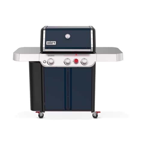
The Ace Hardware Exclusive SA-E 330 Genesis gas grill offers renowned Weber quality, performance, and durability for an enjoyable outdoor cooking experience. Featuring the innovative PureBlu burner system, the grill boasts unique tapered burner tubes for consistent pressure and even heat across the cooking surface. The 9mm stainless steel grates enhance heat retention and searing, while the Flavorizer bars vaporize drippings for flavorful smoke and even heat distribution. The 13,000 BTU Sear Zone Burner intensifies flavor and creates perfect sear marks. The grill includes three stainless steel PureBlu burners for consistent cooking, a Grill Locker for organized storage, and a Flush Electronic Push Button Ignition System for easy starts. Additional features include stainless steel side tables, a Pull & Clean Grease Management System, and a built-in lid thermometer for precision. The Weber Crafted Cooking Grates, Frame Kit, and Griddle are included for a superior grilling experience. The grill is constructed with porcelain housing, uses liquid propane, and comes with a 12-year limited warranty. It has a primary cooking area of 513 square inches, a total cooking area of 641 square inches, and outputs 39,000 BTU from the main burners and 13,000 BTU from the secondary burner.
“This grill is perfect for those who want consistent results and an easy-to-use system,” says Luis, Assistant Manager at Mazzone Ace Hardware. “The Sear Zone Burner is a game-changer for achieving perfect grill marks every time.”
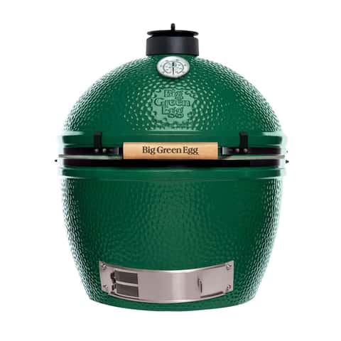
The XLarge model offers a spacious cooking area ideal for large gatherings, capable of handling multiple meals simultaneously. It can accommodate twelve racks of ribs, twenty-four burgers, or two holiday turkeys. This outdoor cooker is celebrated for its high quality, versatility, and ease of use, supporting grilling, roasting, smoking, searing, and baking. It quickly reaches cooking temperature and allows precise heat control with patented airflow systems and a temperature gauge ranging from 150 to 750°F. The ceramic design retains heat and moisture, enhancing natural flavors. Fueled by 100% natural hardwood, it ensures food quality without chemical aftertaste. The product is supported by a limited lifetime warranty and known for excellent customer service. Weighing 219 lbs, it requires assembly and features stainless steel grates, a built-in thermometer, and a primary cooking area of 452 square inches. The grill uses manual ignition and is certified by NSF.
“The Big Green Egg is the ultimate choice for those who want versatility and superior flavor in their cooking,” remarks Liz, Manager at Mazzone Ace Hardware. “It’s a favorite among our customers for its ability to handle any type of outdoor cooking task.”

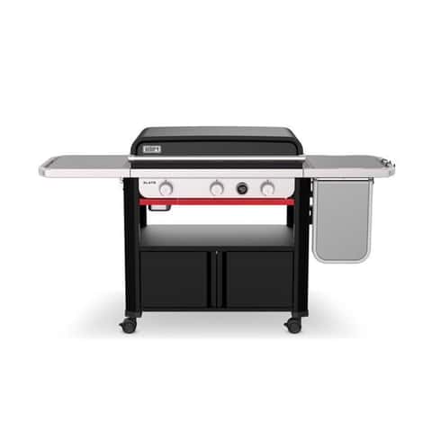
The outdoor griddle offers a versatile cooking experience with its solid rolled steel construction and modern design, catering to various gatherings. It features 60,000 BTUs for adjustable cooking options and a rear grease management system for cleanliness. Suitable for large gatherings, it can accommodate up to 28 burgers. The griddle operates on liquid propane with an electrical ignition and includes a front/side shelf, towel bar, and tool holder. It requires assembly and comes with a one-year limited parts and labor warranty. The primary cooking area spans 720 square inches, supported by four main burners, and the unit is equipped with four wheels for mobility. A grill cover is available separately.
“The Blackstone griddle is perfect for those who love to entertain,” says Shai-Ann, Blind Specialist at Mazzone Ace Hardware. “Its large cooking surface and convenient features make it a favorite for backyard parties.”
This 30-inch rust-resistant outdoor griddle features a pre-seasoned carbon-steel cooktop ready for immediate use, reaching over 500 degrees with consistent edge-to-edge heating. It has 36,000 BTU burners for rapid heating and an even cooking surface. The griddle includes a digital temperature display, a Weber Works caddy for organizing cooking essentials, closed cabinet storage, and an extendable side table for additional workspace. It offers versatile placement with four casters and a right-hand swing-up table for optimized workspace and organization. The left-hand fold-down table and mid-shelf provide extra storage for griddling tools and accessories. The product uses liquid propane, has a porcelain housing, and requires assembly. It features three burners and offers a total cooking area of 540 square inches. The griddle comes with a 5-year limited parts and labor warranty and includes two Weber Works Tool Caddy.
“This Weber griddle is a must-have for those who love precision in their cooking,” notes Matthew, owner of Mazzone Ace Hardware. “Its rust-resistant design and advanced features make it a durable choice for any outdoor setup.”
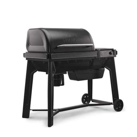
The grill offers a wood-fired flavor experience suitable for grilling, smoking, or baking, with user-friendly controls designed for ease and consistency. Customization is facilitated through P.A.L. Pop-And-Lock options, while WiFIRE connectivity allows remote grill monitoring. Cleanup is streamlined with the EZ-Clean Grease & Ash Keg. Additional features include ModiFIRE accessories for versatile cooking, a fully digital controller, a wired meat probe, and Bluetooth Meat Thermometer compatibility for wireless monitoring. The grill’s design includes easy pellet flavor swapping and convenient staging hooks. Constructed with a steel housing and porcelain-coated cast iron grates, it requires assembly and operates on wood pellets with electrical ignition. The grill measures 46 inches in height, 28 inches in width, and 50 inches in depth, featuring a primary cooking area of 860 square inches. It includes a front/side shelf and comes with a 2-year limited parts and labor warranty.
“The Traeger grill is perfect for those who want to infuse their food with rich, smoky flavors,” says Liz, Manager at Mazzone Ace Hardware. “Its connectivity features make it a modern choice for tech-savvy grillers.”
For all things Ace Hardware, please visit acehardware.com.


